Sunday, June 23, 2013

Salisbury Cathedral


Salisbury Cathedral in England

Above:  A 360-degree panoramic view of the southwest exterior of Salisbury Cathedral, in Wiltshire, England, one of the greatest Anglican cathedrals in the United Kingdom. Built from 1220 to 1258, its Chapter House contains one of the original copies of the Magna Carta.  Photo Credit: Randy Myers, from the 360 Cities website

For an online gallery of photos and a 360-Degree virtual tour of the cathedral's interior, please see the official home page of Salisbury Cathedral.  One may find an overhead map of the cathedral grounds at Wikimapia here.

Formally known as the Cathedral Church of the Blessed Virgin Mary, Salisbury Cathedral is the mother church of the Diocese of Salisbury, and seat of the Bishop of Salisbury.  It is considered one of the greatest examples of Early English Gothic architecture.

The cathedral has the tallest church spire in the United Kingdom (404 ft), according to the Wikipedia article on Salisbury Cathedral here.  "Visitors can take the 'Tower Tour' where the interior of the hollow spire, with its ancient wood scaffolding, can be viewed. The cathedral also has the largest cloister and the largest cathedral close in Britain (80 acres). The cathedral contains the world's oldest working clock (from AD 1386) and has the best surviving of the four original copies of the Magna Carta (all four original copies are in England)."


Above: The Salisbury Cathedral plan.  Source: Wikipedia


Sunday, March 24, 2013

Old Sarum Cathedral: Salisbury Cathedral's Invisible Ancestor

undefined


Above: A museum model of what Old Sarum Cathedral must have looked like, ca. 1200 A.D.  Photo source: Wikimedia commons.

Two miles north of Salisbury, England, and only six miles from Stonehenge lies an empty field that was once the site of Old Sarum Cathedral, the administrative seat of William the Conqueror and, for more than 4,000 years, one of the holiest sites in all of Britain.

A zoom-in zoom-out Wikimapia overview of the Old Sarum grounds may be found here.  For photos, visit the English Heritage Old Sarum page, the Old Sarum Facebook Page or more than 70 visitor photos posted at TripAdvisor.co.uk's Old Sarum Page.

According to Sacred Destinations.com, “Old Sarum was occupied since about 3,000 B.C. by a Neolithic community who built communal burial places, stock enclosures, and large ritual enclosures known as henges (the same sort of structure, on a less monumental scale, as nearby Stonehenge and Avebury Henge).

“From about 500 B.C., during the Iron Age, the hilltop site was given further protection with double ditches and used as an administrative center and fort.  It was later settled by the Romans (from c. 60 A.D.) who called it Sorviodunum. “

The Roman soldiers probably built a shrine to one of their gods on the top of the hill, and Sorviodunum remained a key military stronghold because it was located near a major intersection of several Roman roads, notably the roads from Winchester to Exeter, from Silchester, and from the Severn via the Mindip Hills.

After the withdrawal of Roman troops from Britain, Saxons took over the Old Sarum hillsite around 552 A.D.  They renamed it Searobyrig.  It became a royal estate of the Saxon kings, who re-fortified the hill and used their hill-fort to protect the local farmers and townsfolk for more than 500 years.

After the Norman conquest of 1066, William the Conqueror immediately recognized the importance of Old Sarum, chose it as his residence and began constructing a wooden castle on the site in 1069.  It became the seat of the Norman king’s court and the county government in Salisbury from 1070 forward.  The Norman cathedral that became known as Old Sarum Cathedral was built next to the king’s castle between 1075 and 1092.  Wikipedia provides an Old Sarum Cathedral article with model and maps here.

old sarum, salisbury
Above: An early wood-cut image of Old Sarum.

An Uncomfortable Place for Christian Worship

According to legend, Old Sarum Cathedral was first completed in 1092, but it was hit by lightning and burnt to the ground only five days after the church’s consecration.  The cathedral was rebuilt with stone, and completed around 1190.  Located within a military hill-fort on a gloomy hilltop, the location proved unpopular with superstitious townsfolk, who believed in local legends about the ancient hill on which Old Sarum was founded.

Soon after completion of the stone cathedral, the local council of bishops petitioned the Pope in Rome for permission to build a new cathedral in Salisbury, a much more popular, comfortable and convenient location.  They cited severe weather amongst their reasons for wishing to relocate.

The Pope granted his permission, and the bishops moved to Salisbury Cathedral in 1219.  Old Sarum Cathedral fell into disuse, and the nearby royal castle was finally demolished by King Henry VIII in 1591.

Sarum Missal Remains Popular

Despite the eventual abandonment and demolition of Old Sarum Cathedral, the Sarum Missal or guidebook for the ritual Mass that was practiced at the Old Sarum Cathedral survives and remains popular to this day. 

The Anglo-Catholic Sarum Missal is seen by modern church scholars as a quaint, curious, peculiar and fascinating gem that clearly reflects Catholic practice in Medieval England prior to the Protestant Reformation.

Free ebook copies of the Sarum Missal in several formats may be found at Google Books here and at Archive.org here.

A Wikipedia article on the Sarum Rite summarizes the Missal’s contents and explains the reasons for the continued popularity of the Sarum Rite amongst English-speaking Catholics and church historians.

Nodal Point of 10 Major Ley Lines

Despite the fact that Old Sarum Cathedral no longer exists, the Old Sarum hillsite remains an English Heritage site of great importance to students of British history, astro-archaeology, sacred geometry and ancient pre-Christian religions.  

For example, Stephen Skinner dedicates an entire section to Old Sarum in his 2006 book Sacred Geometry: Deciphering the Code.  Skinner takes pains to distinguish between “unanchored” landscape geometry (fanciful geometry superimposed on landmarks by wishful thinking) and “anchored” landscape geometry. 

The sacred geometry surrounding Old Sarum’s landscape is very well anchored indeed. According to Skinner, the Old Sarum hillsite remains the focal point of “10 main ley lines that fan out over Salisbury Plain connecting it with other prominent sites such as Stonehenge.”

What are ley lines

Skinner says “I believe that ley lines are manmade alignments radiating out from major stone circles and earthwork-ringed settlements . . . . The principle purpose of ley lines was to link major sites, such as Old Sarum and Avebury, with other settlements, hillforts, smaller circles and sacred religious sites . . . .  Effectively the leys formed an intricate and sacred geometry – the geometry of individual sites is related to the horizon points that were determined by the rising and setting points of the Moon and the Sun.  This geometry creates the magic that ties together the whole land, under one chief, king or priesthood.  If this sounds too mystical, then add the additional function of allowing rapid military communication along lines of sight using beacons.”

Skinner lists the following ley lines radiating northward from Old Sarum:

Ley 1: Roman Road toward Dunstable Pond
Ley 2: Toward Figsbury Ring
Ley 3: Portway Roman Road toward Quarley Hill (Fort) then Silchester (pre-Roman town)
Ley 4: Toward Sidbury Camp (Iron Age Fort)
Ley 5: Toward Ogbury Camp, Woodhenge, Durrington Walls
Ley 6: Toward Stonehenge, Salisbury Cathedral, Clearbury Ring, Frankenbury Camp
Ley 7: Toward Yarnbury Castle (Iron Age Fort)
Ley 8: Toward Codford Circle, Wilsbury Ring
Ley 9: Toward Grovely Castle
Ley 10: Toward Bilbury Ring

By comparison with Old Sarum, Stonehenge has only two major ley lines, which indicates that Old Sarum was far more important to the sacred geometry of the British landscape than Stonehenge.  The radiance of so many ley lines from the abandoned field upon which Old Sarum Cathedral once stood suggests Old Sarum was the spiritual and administrative center of the ancient megalithic culture that built Stonehenge and Avebury on Salisbury Plain more than 4,000 years ago.

Sunday, February 10, 2013

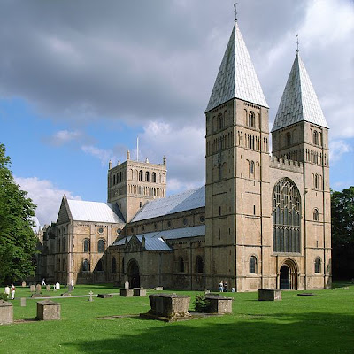
Southwell Minster, Nottinghamshire, England


 Above:  The Southwest face of Southwell Minster, the Cathedral and Parish Church of the Blessed Virgin Mary.  The official website, here, provides surprisingly few photos on its home page, but one may find a truly amazing Southwell Minster Virtual Tour at the Panodesign.co.uk website.

For a 360-degree panoramic view of the interior Nave, see  the Aztec 360 Digital Media site here. At the same website, a 360-pano of the Southwell Minster Chapter House may be found here. 

The Wikimapia page for Southwell Minster provides zoom-in zoom-out interaction with links to surrounding attractions, such as the Big Wood, Nottingham City Center and nearby cities: Sheffield, Kingston Upon Hull and Birmingham.


From Wikipedia:

Built between 1208 and 1520, Southwell Minster has its Norman façade intact, except for the insertion of a large window in the Perpendicular Style to give light to the Norman nave. The particular fame of Southwell is its late 13th century chapter house which contains the most famous medieval floral carvings in England, described by Nikolaus Pevsner as “throbbing with life”.

Above: The Southwell Pulpitum, seen from the Quire  (Source: Wikipedia Commons)
Below: The Presepe window


Saturday, February 2, 2013

St. Paul's Cathedral, London


St Paul's Cathedral, London, UK - In front of the High Altar and choir stalls in London By Matthew Field

Note: Clicking on the link above takes you to the 360-Cities website, where one may find an interactive map of the St. Paul's Cathedral grounds and even more 360-panoramic views.  For a much more detailed map with zoom-in and zoom-out capabilities, please see the Wikimapia St. Paul's Cathedral Page here.


Above: St. Paul's Cathedral in 1896

The St. Paul's Cathedral's Home Page, here, offers slideshows, videos and cathedral history.

From Wikipedia: 

St Paul's Cathedral, London, is a Church of England cathedral and seat of the Bishop of London. Its dedication to Paul the Apostle dates back to the original church on this site, founded in AD 604. St Paul's sits at the top of Ludgate Hill, the highest point in the City of London, and is the mother church of the Diocese of London. The present church dating from the late 17th century was built to an English Baroque design of Sir Christopher Wren, as part of a major rebuilding program which took place in the city after the Great Fire of London, and was completed within his lifetime.

The cathedral is one of the most famous and most recognisable sights of London, with its dome, framed by the spires of Wren's City churches, dominating the skyline for 300 years. At 365 feet (111 m) high, it was the tallest building in London from 1710 to 1962, and its dome is also among the highest in the world. In terms of area, St Paul's is the second largest church building in the United Kingdom after Liverpool Cathedral.


 Above: St. Paul's Cathedral survives bombing, 28 December 1940

St Paul's Cathedral occupies a significant place in the national identity of the English population. It is the central subject of much promotional material, as well as postcard images of the dome standing tall, surrounded by the smoke and fire of the Blitz. Important services held at St Paul's include the funerals of Lord Nelson, the Duke of Wellington and Sir Winston Churchill; Jubilee celebrations for Queen Victoria; peace services marking the end of the First and Second World Wars; the wedding of Charles, Prince of Wales, and Lady Diana Spencer, the launch of the Festival of Britain and the thanksgiving services for the Golden Jubilee, the 80th Birthday and the Diamond Jubilee of Elizabeth II. St Paul's Cathedral is a busy working church, with hourly prayer and daily services.


Above: Interior view, looking upward at the Dome of St. Paul's Cathedral    Source: Wikimedia Commons


Films and TV programmes featuring St Paul's Cathedral include:
  • St Paul's Cathedral has appeared numerous times in Doctor Who, most notably the 1968 episode, The Invasion. In one scene, a group of Cybermen are shown climbing out of some manholes in Central London, before descending a stairway in front of the Cathedral.
  • Saint Paul's is seen briefly in the Goodies episode, Kitten Kong. During his rampage through London, Twinkle does damage to various London landmarks, including Saint Paul's Cathedral, which has its dome knocked off when he bursts out of the centre of the famous church.
  • Harry Potter and the Prisoner of Azkaban shows the Geometric Staircase in the South West Bell Tower.
  • The Madness of King George shows the Geometric Staircase in the South West Bell Tower.

Above: The Geometric Staircase at St. Paul's cathedral is the setting for the opening sequence of the 2009 film Sherlock Holmes, and also appears in The Madness of King George
  • Mary Poppins shows the front and outside of the Cathedral, though it shows the space from the missing clock, when that was caused by bombing during World War II, 30 years after the film was set.
  • Sherlock Holmes (2009) shows the North side of the West Steps, and the Geometric Staircase in the South West Bell Tower.
  • Lawrence of Arabia (1962) shows the exterior of the building and T E Lawrence's bust. 


The Spherical Images interactive photography website provides a 360-degree gigpixel pano (15.5 billion pixels) of the interior of St. Paul's Cathedral in "beyond HD" quality, which has been reproduced as an interactive pano in Wired Magazine, but it is very heavy in more ways than one.

Below: The Floor Plan of St. Paul's Cathedral from Picturesque England: Its Landmarks and Historic Haunts by Laura Valentine (1891)


Sunday, January 27, 2013

Wakefield Cathedral, West Yorkshire

Above: Wakefield Cathedral, formally the Church of All Saints Wakefield, is the cathedral of the Church of England's Diocese of Wakefield.  Located in West Yorkshire, it is not far from Leeds, Manchester and Sheffield.  One may find a Wikimapia overview of the cathedral grounds here.

The Wakefield Cathedral Home Page, here, provides a slide show and video of the interior.

For a 360-degree panorama: Please see the BBC's Bradford and West Yorkshire Site here.  It requires a browser plug-in.

The Wakefield 366 Page at Flickr also provides more than 250 interior views, including beautiful shots of some of the cathedral's best-known features: its medieval stained glass, the furniture of the St. Mark chapel, the high altar, a 17th-century rood-screen, the rererdos of John Oldrid Scott, and many carvings of strange figures, including mythical beasts and a green man.  

Wikipedia says the cathedral tower has a ring of 14 bells and "no more than 12 bells are usually rung at any one time."  The Wakefield cathedral choir has been featured on BBC radio's Songs of Praise and Choral Evensong programs.


From Wikipedia: The Vicar of Wakefield "is a novel by Irish author Oliver Goldsmith. It was written in 1761 and 1762, and published in 1766, and was one of the most popular and widely read 18th-century novels among Victorians. The novel is mentioned in George Eliot's Middlemarch, Jane Austen's Emma, Charles Dickens' A Tale of Two Cities and David Copperfield, Mary Shelley's Frankenstein, Sarah Grand's The Heavenly Twins, Charlotte Brontë's The Professor and Villette, Louisa May Alcott's Little Women and in Johann Wolfgang von Goethe's The Sorrows of Young Werther, as well as his Dichtung und Wahrheit."

Free and downloadable copies of The Vicar of Wakefield, including audio book copies, may be found at the Internet Archive website here.

From Wikipedia:

Wakefield Cathedral, or the Cathedral Church of All Saints in Wakefield, West Yorkshire is the Anglican Cathedral for the Diocese of Wakefield and seat of the Bishop of Wakefield.

Originally the parish church, it has Anglo Saxon origins and after enlargement and rebuilding has the tallest spire in Yorkshire. It is the tallest building in the City of Wakefield.

The cathedral is built on the ruins of an ancient Saxon church  A church in Wakefield is mentioned in the Domesday Book of 1086. In 1090 William II gave the church and land in Wakefield to Lewes Priory in Sussex and shortly after that a Norman church was built.

The cathedral is situated on a hill on Kirkgate in the centre of the city. The Norman church was rebuilt in 1329, and apart from the tower and spire, rebuilt and enlarged in 1469. The church was reconstructed and altered at various times and its spire, damaged in a violent gale, was renewed in 1823. Up to the 16th century the church was known by the Anglo Saxon All Hallows and after the Reformation changed to All Saints.

The cathedral was largely rebuilt in the Perpendicular Gothic style in the early 15th century and, after years of neglect in the 18th century, owes its current late mediaeval appearance to a Victorian restoration by Sir George Gilbert Scott and his son John Oldrid Scott between 1858 and 1874


The cathedral walls are clad in ashlar sandstone. On the south wall is a porch, with a wrought iron gate and a sundial over the door arch. The wall of the north aisle is the oldest part of the church dating from about 1150. The nave piers date from the 12th and 13th centuries and the arcade and chancel arches date from the 14th century. The late 15th-century chancel now serves as the choir. The nave's original stone vaulted roof has been replaced with wood. The 15th-century wooden ceilings over the nave and aisles have carved bosses


Above: A 19th-century view of Wakefield Cathedral, during the times of Jane Austen (1815)

Thursday, January 17, 2013

Wells Cathedral, Somerset, England


Above: Wells Cathedral, the Cathedral Church of St. Andrew, Wells, Somerset, England. Diocese of Bath and Wells, District of Canterbury. See a Wikimap of the Cathedral Grounds here. The Wells Cathedral is located in southwestern England, south of Bristol and Bath.

Photo Source: Wikimedia Commons, Seier & Seier's Photostream, 25 July 2010


 Cloister, Wells Cathedral in City of Wells
Photographer: Noel Jenkins

The Official Wells Cathedral website, here, includes slide shows and videos.

According to Wikipedia, "Wells Cathedral is a Church of England cathedral in Wells, Somerset, England. It is the seat of the Bishop of Bath and Wells, who lives at the adjacent Bishop's Palace.

"Built between 1175 and 1490, Wells Cathedral has been described as 'the most poetic of the English Cathedrals.' Much of the structure is in the Early English style, much enriched by its sculptural aspects and the vitality of the carved capitals in a foliate style known as “stiff leaf”. The eastern end has retained much original glass, rare in England. The exterior has a fine Early English façade and a large central tower.


"The first church was established on the site in 705. Construction of the present building began in the 10th century and was largely complete at the time of its dedication in 1239. It has undergone several expansions and renovations since then and has been designated by English Heritage as a Grade I listed building, and Scheduled Ancient Monument.

 Above: Wells Cathedral's Astronomical Clock.  Below:  The steps of the Chapter House and elaborate metal work on the undercroft door.


A Virtual Tour of the Cathedral of Wells may be found at the Re:Quest website, here.  It requires a plug-in to be downloaded for viewing, but supplies both the floorplan and a dozen different views.

Columbia University's Medieval Architecture Virtual Tour page provides an excellent 360-degree Virtual Tour of Wells Cathedral, and also requires a QuickTime7 plug-in.  Navigation on their page is a bit weird. Use the position slider on your computer's bottom toolbar to go all the way to the right-hand end of the Columbia University page, and way over there you will find links to an Exterior View of the West Facade, an Exterior View of the Cloister, an Interior View of the Chapter House, a second Interior View of the Chapter House, an Interior View of the Choir, an Interior View of the Lady Chapel, an Interior View of the Nave, an Interior View of the Main North Transept, an Interior View of the South Main Transept, an Interior View of the Stairs in the Chapter Hall, and, last but not least, an Interior View of the West Rose Window at the Tribune Level.


The Nave, Wells Cathedral in City of Wells

Above: The Wells Cathedral's Floor Plan, from Wikipedia.


Saturday, January 12, 2013

Westminster Abbey, London


Westminster Abbey in London

For more 360-degree panoramic views:

http://www.360cities.net/search/Westminster-Abbey

The Collegiate Church of St Peter at Westminster, popularly known as Westminster Abbey, is a large, mainly Gothic church, in the City of Westminster, London, located just to the west of the Palace of Westminster. It is the traditional place of coronation and burial site for English, later British and later still (and currently) monarchs of the Commonwealth realms. The abbey is a Royal Peculiar and briefly held the status of a cathedral from 1540 to 1550.